Mangaia Island; (also known as Auau Enua, which means terraced)
Here are just a few pictures of Mangaia, where it is located in the south pacific, and some beautiful scenery and views.
Enjoy!
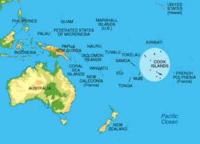 Mangaia is the southernmost island of the 15 islands of the Cook Islands. And is second in size to Rarotonga, the capital.
The Cook Islands is NE of New Zealand, E of Samoa, Niue and Tonga, and W of Tahiti.
Mangaia is the southernmost island of the 15 islands of the Cook Islands. And is second in size to Rarotonga, the capital.
The Cook Islands is NE of New Zealand, E of Samoa, Niue and Tonga, and W of Tahiti.
Mangaia is estimated by archaeologists to be over 18,000,000 years old, making it one of the oldest islands in the Pacific ocean.
Mangaia Island.
 |
| Mangaia: Oneroa is the main village on the W coast of the island. The other 2 villages on the island are Ivirua (NE) and Tamarua (S). |
 |
| View from plane of Mangaia. |
 |
| View from cockpit of airport before landing. |
 |
View from plane prior to landing.
 |
View from plane coming into land at airport.
|
|
 |
Mangaia International Airport.
|
 |
Plane just landed at airport.
|
 |
| Walking Down the Main Road Gap in the Makatea (raised coral reef) in Oneroa (main village). |
 |
Walking up the Main Road Gap in the Makatea in Oneroa (main village).
 |
Driving Down the Main Gap in the Makatea (Oneroa Village).
|
 |
Driving Down the Main Gap in the Makatea (Oneroa Village).
|
 |
Driving Down the Main Gap in the Makatea (Oneroa Village).
|
 |
| Driving Down the Main Gap in the Makatea (Oneroa Village) |
Driving Towards Mangaia International Airport.
Mangaia International Airport.
Mangaia International Airport, View Towards Ivirua Village.
Coral Reef and View Back Towards Airport (Ivirua).
View From Near Middle of Island to Oneroa Village.
View From Near Middle of Island Towards Oneroa.
Looking Towards Lake Tiriara
 |
Maumaukura Lookout - Tamarua.
|
View of Tamarua Taro Plantations Below From Maumaukura Lookout.
View of Tamarua Taro Plantations From Maumaukura Lookout.
View of Tamarua Taro Plantations From Maumaukura Lookout. |
 |
| Beach and Lagoon near Tuaati. |
 |
Lagoon and coral reef at low tide - at Tuuati.
 |
| Beach and lagoon by Tuaati. |
|
 |
| Great Swimming Spot - Tuaati |
 |
| View from plane of Ivirua village. |
 |
| View of Ivirua village from plane. |
 |
| View of Ivirua village from plane. (airport top right) |
 |
| View of Interior of Island Towards Ivirua Village. |
 |
| View of Interior of Island. |
 |
| View of Interior of Island. |
 |
| View of Interior of Island. |
 |
| Part of the Planted Pinus Radiata Trees on Mangaia. |
|
|
 |
| Saragossa Shipwreck Site Near Tamarua. |
 |
| Saragossa Shipwreck Anchor - Near Tamarua. |
 |
| Saragossa Shipwreck Site Near Tamarua. |
 |
| Mangaia Habour |
 |
| Mangaia Habour |
 |
| Post Office Inlet |
More Images will be continually added.


I really enjoyed the photos of your beautiful island, I would love to visit one day.
ReplyDeleteI found your site while searching for the Saragossa. My Grandfather James Payne was an apprentice on the ship when it was wrecked on Mangaia, and it is hard to obtain much information about the ship.
It's really good to know that the wreck area is a nature reserve.
Best Regards
Tony Payne